November 25, 2016

New Zealand Cycle Touring Route - Otorohanga to Stratford


This route allows you to ride south down the west side of the North Island to Taranaki. The ride will take you through back country New Zealand, where in parts the forest is as it was in most of the North Island in pre European times. While the ride total distance is only 241 kilometres the topography is very hilly in an isolated part of New Zealand which is known as the Forgotten Highway. The country is isolated and hilly with lots of climbing as well as shingle roads. The remoteness and the landscape are part of the attraction of riding the Forgotten Highway but you need to be fit enough for the hills and leave yourself plenty of time to enjoy the ride. In its favour the road has little traffic and the some of the few motorists we met on the road stopped for a friendly conversation.


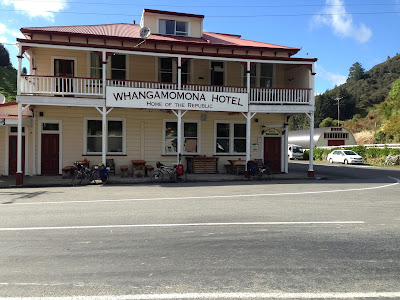
Republic of Whangamomona Hotel


We took the back road from Otorohanga to Waitomo a distance of 14ks and spent some time in the Ruakuri reserve and walkway which is well worth a look. From Waitomo, we made our way to Piopio via the Aria and Waitewhena roads a distance of 32 kilometres. We stayed in the Tui Park camping ground which is a a great spot for cyclists.
 
Piopio camping ground

The next day was a 57 kilometre ride from Piopio to Ohura. There is not a lot of accommodation to be found in Ohura but we stayed in a Yurt which was good.

From Ohura to Whangamomona is 58 kilometres and includes the Tahora Saddle and the Tangarakau Gorge which is unsealed.


We stayed in a farm stay at the top of the Tahora Saddle which has a fantastic camping ground right at the summit. In the morning we coasted down the hill into Whangamomona where the hotel is a great place for a meal. 

Tahora Saddle


From Whangamomona to Purangi is 32 kilometres but there are two saddles the Whangamomona and the Pohokura to climb. At Purangi there is a farm stay the Old School House which is a good place for cyclists to stay.


From
To
Distance
Otorohonga
Waitomo
14.4
Waitomo
Piopio
32.4
Piopio
Ohura
57.0
Ohura
Whangamomona
57.9
Whangamomona
Purangi
31.5
Purangi
Stratford
47.9
Total

241.1


September 06, 2016

Cycling Ninety Mile Beach Northland


Route Description by: Kit O'Halloran

Last summer, I at last,got to ride Ninety Mile beach on my fat tyre Kona bike. This was a long-held ambition of mine. Here are some notes on my experience that may be of use to others.
Low tide on 90 Mile Beach provides the longest flat ride you will find in New Zealand. Here you will find a pristine carpet of sand rolling out in front of you for 84 km with only the ocean on one side and undulating sand dunes with the occasional background of pine forest on the other side. There is no evidence of human presence apart from the occasional tour bus and 4 wheel drive vehicles of the surf fishermen.

You are able to enjoy the freedom of a broad expanse of hard sand with no need for a helmet.
However, once you have reached the sand, there is some urgency about your endeavour, because you must find your way off the beach ahead of the incoming tide. The rule of thumb is that you can enjoy just 2 hours either side of low tide when the sand will be firm enough to ride on.

So if you ride from the northernmost entry point at the Te Paki Stream all the way to Ahipara you will have an 80 km ride, and, riding at 20km/hr you will have no time for stopping for a thermos of tea or to search for the missing toheroa beds.
Other features of the ride are the high tide island (Te Wakatehaua) at the Te Kao road access and the extensive tuatua beds that can be found at intervals along the whole length of the beach. The tuatua beds are evident from the tiny tubes of sand pushed up by every individual shell fish around the mid-tide mark. The high tide island can be reached from the beach at all times except full tide, but on the ocean side is for ever exposed to the full force of the waves.

Road access to the beach is available at four locations as shown on the map above and referred to in the table below.
Route Distance
Northern end to Te Paki Stream 3.9km
Te Paki stream to Te Kao 19.5km
Te Kao to Bluff 12.4km
Bluff to Hukutere 17.1km
Hukutere to Waipapakauri 17.5km
Waipapakauri to Ahipara 13.5km
Total Distance 89.9km

The Te Paki Stream access is the most used for the northern end of the beach. However,this includes following the stream bed for the first 2 kms from the beach. The creek is not tidal but has a variable sandy bed that makes it difficult to stay on your bike. Only the most experienced mountain bikers will be able to ride the whole length of this. Most will choose to walk their bike over the greater part of the creek section.

For all rider's it is very likely that sand will find its way into your disc brakes and will acquaint you of this by emitting a horrible scraping noise. Sand will also get onto your chain and sprockets. The sand damage is unlikely to be catastrophic but should be inspected and attended to on leaving the creek. I recommend a dry lube of your chain and rings, before you start because the sand will either not stick to these or can easily washed off.

The adjoining road section of the link to State Highway 1 has a gravel surface.
Accesses to the beach at Ta Kao, Bluff and Hukatere are on hard to find unsealed, unmarked roads, many of them through pine forests.

The Waipapakauri access is a good sealed road, and I used this as the starting point for my ride up the beach. I left the beach via the Te Paki Stream. Accommodation is available in cabins close to the beach at Waipapakauri (Ninety Mile Beach Holiday Park) and Ahipara (Ahipara Holiday Park).
At the northern end the only facilities are at the Waitiki Tourist Complex, where there is a shop, cabins, bar and restaurant some 5kms south from where the Te Paki Stream access road joins SH1.

February 09, 2016

Cycleways in the USA

In the United States, there is also a trend to build car- free roads, lanes and bike paths as in Europe.
This link includes examples of car - free roads across the USA.
http://www.bicycling.com/rides/travel/10-best-car-free-bike-paths-in-the-usa  

The New Zealand cycle trail network provides similar off-road cycling experiences that are providing good opportunities for cyclists of all abilities to see New Zealand on a bike. The cycle trail networks are mostly geared for people to visit on day trips rather than as part of a cycle tour of New Zealand but they can be incorporated into a cycle tour with the proviso that not all of the cycle trails are suitable for touring bikes with full loads.

The great news is that every year significant progress is being made to make New Zealand more cyclist friendly and that this is part of a worldwide trend.

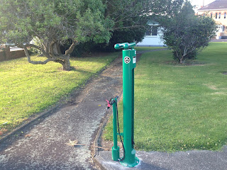
Cyclist Friendly - Bike pump & Repair tools - North Western Cycleway